Columbia River Links

Phase II Implementation Plan

The Phase II Implementation Plan (P2IP) is a 20 year, $300M plan developed by the Upper Columbia Unified Tribes (UCUT) to conduct studies to inform the feasibility of salmon reintroduction above Chief Joseph and Grand Coulee Dams on the Columbia River. In 2023, the Bonneville Power Administration, Bureau of Reclamation, and the U.S. Army Corps of Engineers (USACE) agreed to provide funding and technical support for the P2IP. 

Once the UCUT complete the study, there would be a recommendation on implementation, which would require additional funding. This would be phase three, in approximately 2042. USACE has signed a Finding of no Significant Impact (FONSI) as part of the National Environmental Policy Act compliance process for the P2IP, April 21, 2025. It is available here: https://usace.contentdm.oclc.org/utils/getfile/collection/p16021coll7/id/27780. The FONSI documents that there would be no significant adverse effects on the quality of the environment from implementation of the P2IP.   Bonneville Power Administration and the Bureau of Reclamation participated as co-leads on the NEPA process.

Columbia River Basin

A barge transits down a river(Above) A barge makes its way down the Columbia River.

The Columbia River Basin is a large and complex system with variable stream flows and weather patterns. Fourteen federal projects (dams) operated by the U.S. Army Corps of Engineers and Bureau of Reclamation in Idaho, Montana, Oregon and Washington make up the system. The economic vitality of the region and its Tribes, communities, industries, and fish and wildlife species all depend on the system's ability to provide for multiple uses, including flood risk management, hydropower generation, navigation, irrigation, recreation, water quality, and fish and wildlife. The U.S. Army Corps of Engineers is committed to managing the Columbia River System responsibly, in accordance with the Congressionally authorized project purposes.

Columbia Basin Dams

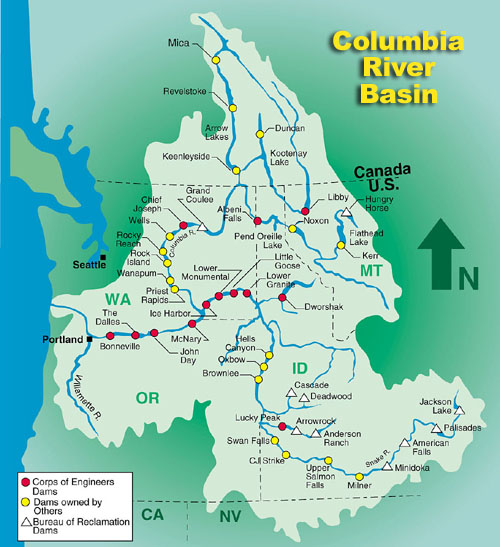
A map opf the Columbia River Basin and Columbia River Dams. A red dot indicates USACE Dams, a yellow dot indicates dams owned by others, and a white triangle indicates US Bureau of Reclamation DamsThe Columbia River Basin is North America's fourth largest, draining about 250,000 square miles and extending throughout the Pacific Northwest and into Canada. There are more than 250 reservoirs and around 150 hydroelectric projects in the basin, including 18 dams on the main stem of the Columbia River and its primary tributary, the Snake River.

The U.S. Army Corps of Engineers operates nine of 10 major federal projects on the Columbia and Snake rivers, and Dworshak Dam on the Clearwater River, Libby Dam on the Kootenai River, and Albeni Falls Dam on the Pend Oreille River. The federal projects are a major source of power in the region, and provide flood damage reduction, navigation, recreation, fish and wildlife, municipal and industrial water supply, and irrigation benefits.

Dams and Salmon

USACE operates eight dams on the lower Columbia and Snake rivers affecting the habitat and migration of anadromous salmon and steelhead species. These are Bonneville, The Dalles, John Day and McNary on the lower Columbia; and Ice Harbor, Lower Monumental, Little Goose and Lower Granite on the lower Snake River. The dams impede juvenile and adult migrations to and from the ocean by their physical presence and by creating reservoirs. The reservoirs behind the dams slow water velocities, alter river temperatures, and increase predation potential. Reduced velocity increases the time it takes juveniles to migrate downstream, higher water temperatures may have adverse effects on juvenile and adult behavior, and predators find prey more easily in slower-moving water. However, all eight dams have juvenile and adult fish passage facilities enabling fish migration; and, the dams are operated to improve passage as well as reservoir conditions for fish.

Columbia Basin News

U.S. Army Corps of Engineers waives day use fees at recreation areas in observance of America’s 250th birthday celebration
6/24/2026
The U.S. Army Corps of Engineers today announced that it will waive day use fees at its more than 2,800 USACE-operated recreation areas nationwide in support of America’s 250th birthday celebration,...
Weekend heat spike could prove deadly
6/11/2026
The National Weather Service is predicting a spike in temperatures this weekend, with highs in the mid-to-upper 90s along the Interstate 5 corridor. High heat like this often drives people to seek...
U.S. Army Corps of Engineers waives day use fees at recreation areas in observance of Army Corps of Engineers’ Birthday
6/9/2026
The U.S. Army Corps of Engineers today announced that it will waive day use fees at its more than 2,800 USACE-operated recreation areas nationwide in observance of its birthday, June 16...
Summer recreational lock schedule now in effect on Columbia River
6/3/2026
Recreational boaters navigating the three lower Columbia River dams—Bonneville, The Dalles, and John Day—now have expanded access to pass through the navigation locks for the summer season...
New 20-year plan finalized to manage Columbia River dredged material
6/2/2026
The U.S. Army Corps of Engineers, Portland District, has finalized a 20-year plan to maintain the lower Columbia River’s deep-draft navigation channel, a critical artery for the nation’s economy...
Spring fish operations begin on Snake, Columbia rivers
4/8/2026
Spring fish passage operations began April 3 at federal dams on the lower Snake River and will begin April 10 on the lower Columbia River...